From Friday, April 19th (11:00 PM CDT) through Saturday, April 20th (2:00 PM CDT), 2024, ni.com will undergo system upgrades that may result in temporary service interruption.
We appreciate your patience as we improve our online experience.
From Friday, April 19th (11:00 PM CDT) through Saturday, April 20th (2:00 PM CDT), 2024, ni.com will undergo system upgrades that may result in temporary service interruption.
We appreciate your patience as we improve our online experience.
Contact Information
Name of the College: Hindustan University, Chennai
Name of the Team Members along with their year of graduation: Nitish Kumar(2015), Sandeep Kumar (2015), Puranjan Das (2015), Mohit Gouda (2015), Naveen Kumar Reddy (2016)
Name of the Faculty Guide: Prof. G. Mutthukumarn
Project Information
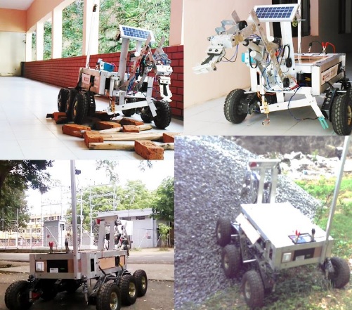
Project Title: Rover InDUS [Industrial, Defense & Unmanned Ground system]
Hardware & Software Used: NI-myRIO, LabVIEW 2013, NI-Vision Acquisition 2013, NI-FPGA
What challenge/problem are you trying to solve through your application:
Design and build the next generation of rovers that will one day work for the betterment of mankind.
How does your application solve the above mentioned challenge/ problem:
In our system we have 1 sever and 4 client. Server is capable to perform the entire task but to have better monitoring system the task has been dived into clients they will take care their respective departments. All the system is connected in the single network of the myRIO Wi-Fi.
The sensors data display which actually takes screen shot of the server system. The sensors which are mention in the rover electronics that data is displayed here.
Drive system consist with front camera and the complete orientation is shown using the gyro & accelerometer sensors and meanwhile the angle between horizontal and the respective axis.
Detection correct soil proportion using moisture sensor and meantime it shows the status of probe and the graph related to it and the data acquisition is done for the same.
Feedback of Actuators stroke length 30m of robotic arm and arm absolute angle with respect to horizon. (0-60 degree). The front camera of the robotic arm to visualize it perfectly.
Usage:
Features:
Images:
Embedded video:
